
From data to decision: How SYNAPSIS helps bridge teams turn information into action
Bridge teams have never had access to more information.
Radar, ECDIS, weather data, route optimisation services, and specialised sensors continuously provide information about the vessel and its environment. Yet more information does not automatically make navigation easier.
For many crews, additional data still means additional work. Information must be compared, verified and interpreted before it can support a decision. As the amount of available data continues to grow, the challenge is no longer collecting information. The challenge is turning it into understanding.
One trusted picture instead of fragmented information
This is exactly the role of modern integrated navigation systems such as SYNAPSIS from Anschütz. The global Anschütz Group is a leading supplier of navigation systems, ranging from gyrocompasses and autopilots to integrated navigation and bridge systems.
Within SYNAPSIS, the applications Radar, ECDIS, and conning operate on a shared and validated data backbone. At the centre of the system is the Bridge Integration Platform (BIP), which continuously collects, validates, and distributes information across all bridge workstations. The result is one consistent operational picture available throughout the bridge.
Instead of comparing multiple sources, bridge teams work with one system logic and one shared understanding of the situation. Less time is spent cross-checking displays and validating information. Situational awareness improves, and cognitive workload is reduced. Crews can focus on assessing situations and making decisions rather than managing information.
Better use of information
Recent SYNAPSIS software enhancements demonstrate how this common operational picture continues to evolve. New functions focus on practical bridge workflows, helping crews assess situations faster, reduce workload, and maintain a clearer picture of their surroundings.
Prediction tools help crews assess manoeuvres before they are executed. Dedicated docking modes support close-quarter operations with task-oriented displays. New route-planning functions improve safety in confined and shallow waters. The updated conning interface further improves readability and at-a-glance assessment of critical information.
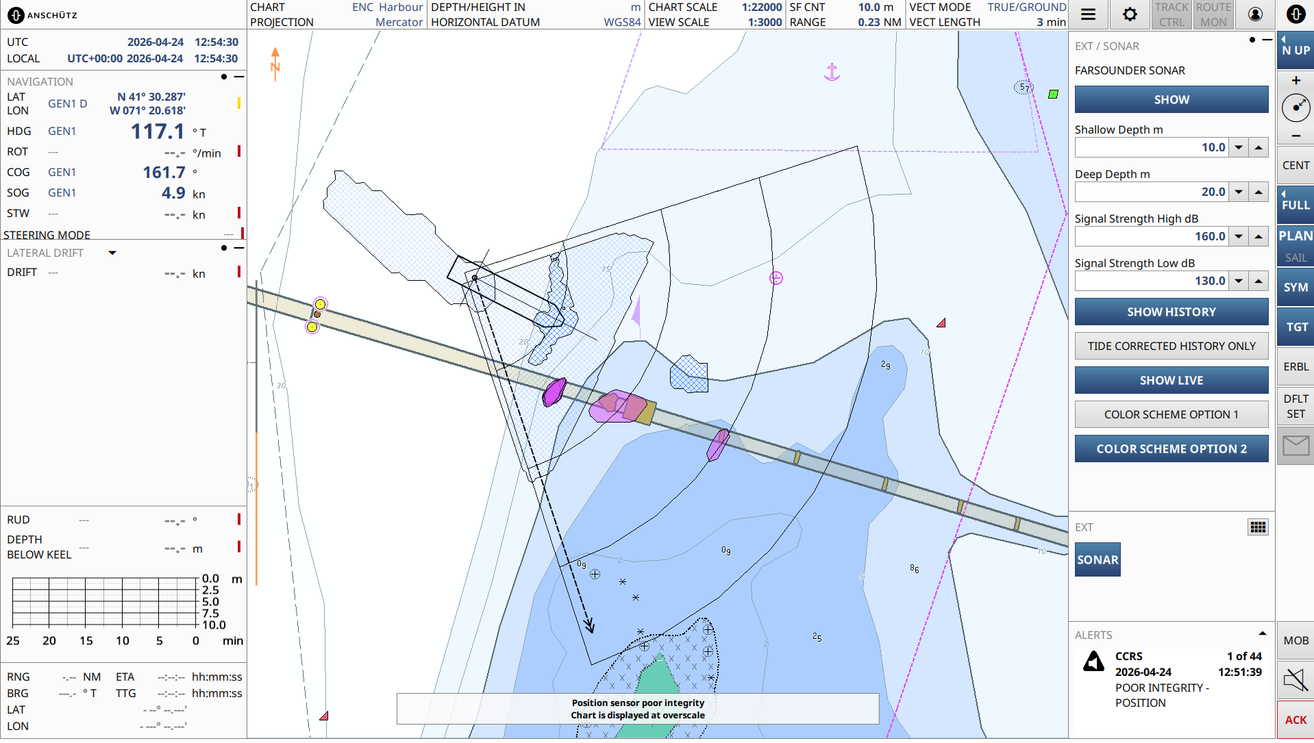
One of the most important additions is Generic Overlay. For the first time, external geo-referenced information can be integrated directly into ECDIS and displayed alongside navigation data within the same operational context.
A forward-looking sonar system has already been connected as a prototype. Instead of switching between systems, operators can assess chart information, route information, and sonar data within one trusted picture. This improves understanding of the environment around and ahead of the vessel whilst supporting more precise manoeuvring and earlier recognition of potential hazards.
What matters is not simply having more information available. What matters is bringing relevant information together in a way that supports understanding and action.
Building the bridge to S-100 and future assistance
The next major step will come with the introduction of S-100 services. From 2028 onwards, navigators will gain access to additional maritime information such as additional bathymetric information, water levels, currents, and other dynamic environmental data layers.
A navigator approaching shallow waters has different informational needs than a navigator crossing an ocean passage. More information alone does not solve this challenge. The value comes from bringing information together within one trusted operational picture.
This is where the SYNAPSIS benefit becomes visible. Today's platform already integrates radar, ECDIS, conning data, and external information sources. S-100 services and additional sensor integrations will further enrich this picture. The progression is straightforward: more data creates a better picture, and a better picture creates better understanding.
Future assistance technologies will build on this foundation. By highlighting relevant information, recognising risks earlier and structuring complex situations, they may help bridge teams focus their attention where it matters most.
The navigator remains fully responsible for every decision. The role of the system is to provide the best possible basis for that decision. Even demanding situations such as dense traffic, confined waters or GNSS disruption can be handled more effectively when information is continuously validated, consolidated, and presented within one consistent operational framework.